Water & Land Management
The Parrett Catchment
 The catchment of the River Parrett is located in the southern part of Somerset. It drains from the Quantocks, Blackdown Hills and Mendips, flowing through the low-lying Somerset Levels and Moors to the Bristol Channel at Bridgwater Bay. It includes the tributaries of the rivers Isle, Tone, Yeo and Cary.
The overall catchment area is about 1,700 square kilometres, and has a population of around 300,000. It’s a rural catchment, with urban areas making up only four per cent of the total area. Its main urban areas include Taunton, Bridgwater and Yeovil. The rivers and streams flow from their source in the hills in the southwest and east of the catchment. They flow in a north and westerly direction down into an extensive lowland floodplain, before flowing out into the Bristol Channel through the Parrett Estuary.
The underlying rock has a significant influence on the catchment’s response to rainfall, with high run-off from the impermeable uplands in the east and waterlogging of the lowlands. The area does not have any major aquifers so groundwater flooding is not a major risk.
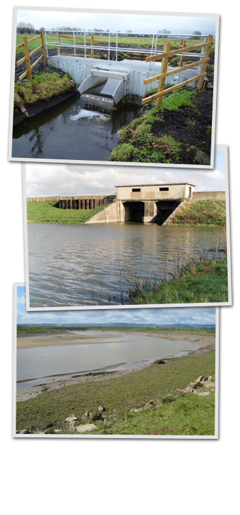
The major rivers start in the steep uplands, then flow through flat lower moors, where they are embanked and in some places perched above the surrounding floodplain. The lower reaches of the rivers Tone and Parrett are tidal for some 30km (18.6miles) from the Severn Estuary. The steepness of the uplands, coupled with the geology and soil conditions, generates quick run-off from short intense rainfall. In the Somerset Levels and Moors, flooding is caused by longer duration storms or a series of storms of low intensity. The high-level embanked channels overflow and floodwater is stored in the moors before it can reach the estuary. The capacity of these channels can be significantly reduced by high tidal conditions backing up the Parrett. The Environment Agency and Internal Drainage Boards have an important role in managing land drainage within these low-lying moors via a network of water level control structures (e.g. pumping stations, sluices and tidal flaps).
A significant part of the low-lying Somerset Moors are designated Special Protection Areas and a Ramsar site, which depend upon flooding. Other areas have national conservation designations.
The area is also rich in archaeological sites, some of which depend on waterlogged conditions for their preservation.
If you would like to know more about biodiversity and heritage click here.
![]() Project delivered by JBA ConsultingImage Copyright Information
Project delivered by JBA ConsultingImage Copyright Information
![]() Website designed & built by The Fuse Creative Marketing
Website designed & built by The Fuse Creative Marketing
Any enquiries on flood risk management activities within the Somerset WAVE area should be addressed to the Environment Agency: SouthWestEnquiries@environment-agency.co.uk
Any enquiries on other aspects of the web site should be addresses to JBA Consulting: somersetwave@jbaconsulting.com